|
<< Click to Display Table of Contents >> Map |
  
|
|
<< Click to Display Table of Contents >> Map |
|
The map provides an overview of the health of system and allows you perform common actions on specific devices.
Note: In order to use the integrated map, an active internet connection is required. Also, when setting up you Central for the first time, enter a valid zipcode so that the map is correctly centered to your vicinity (you can easily change this using the Central System Setup screen).
Tip: Use the Find feature to easily locate devices and center devices on the map.
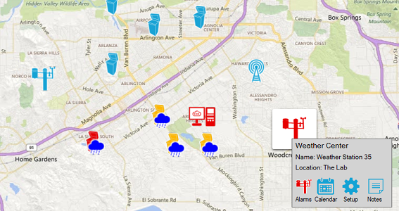
The map contains several icons that represent their status:
|
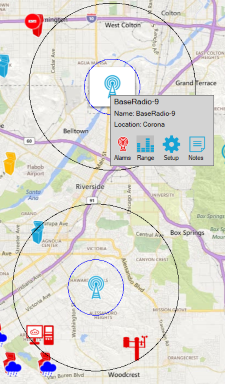
Controllers, weather stations, base radios, repeaters and central PC are normally blue when there are no errors. The ideal condition is to have all icons as blue so that any changes or alarms that occur can be easily identified. |
|
A controller can have a blue rain cloud symbol overlaid if the controller is in rain, wind or freeze shutdown state |
|
A controller can have a red no-entry symbol overlaid if the controller offline. Note: If a controller is offline, you will not be able to communicate with it and scheduled events will have communicate with controllers that are offline. |
|
A controller, weather station or central PC that has alarms that have not been cleared will be colored red. |
|
A controller that is associated with a specific weather station or radio will be highlighted in yellow when you click the mouse on a weather station icon or a radio icon. This provides an easy way to identify a microclimate and also to check that controllers are within a radio's range. |
|
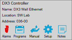
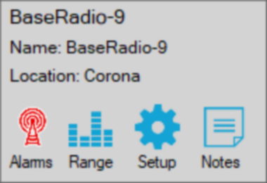
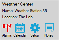
If you click on an icon on the map, a panel will appear that summaries the device by displaying it name, location name. Depending on the device, addition information is presented. Located on the panel are buttons that let you perform common operations e.g. •on a controller, view alarms, edit programs, perform manual blue panel operations, setup the controller and edit notes. •on a weather station, view alarms, view the weather calendar, setup the weather shutdown conditions for the microclimate and edit notes. •on a radio, view alarms, view the range markers, setup the base radio and edit notes. The range markers show a range of 1-mile and 3-mile radius. |
|
You can zoom into the map using the zoom control at the bottom left, alternatively, use the mouse wheel. If you zoom using the mouse wheel, the zooming will occur centered around the mouse pointer. |
|
Use the map icon in the toolbar or using the map menu to toggle between road view and aerial view. |
See Also