|
<< Click to Display Table of Contents >> Setup |
  
|
|
<< Click to Display Table of Contents >> Setup |
|
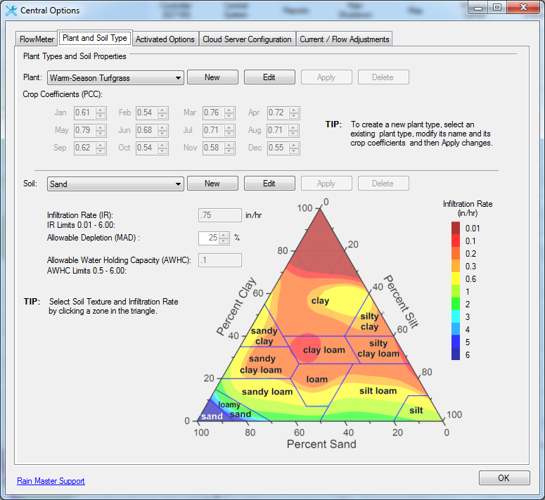
Advanced ET uses all of the Basic ET setup while adding some additional requirements (see Basic ET). Those extra requirements potentially include the Plant and Soil setup if the default options are not sufficient for the needs of the system as well as the inclusion of a rain microclimate to pair with the ET microclimate. Custom plants and soils can be created via Central Options:
Once the prerequisites outside of the ISC form have been established, the remaining requirements exist in the station grid. These requirements will be highlighted with warnings of values outside of the expected range for each column. The columns that require review are Max Allowable Depletion, Soil Type, Plant Type, Root Zone Depth, Station Efficiency, Percent Adjust, Site Microclimate, Slope, and Precipitation Rate.


Max Allowable Depletion represents the level of depletion that is acceptable until the station requires irrigation. Rain Master suggests this value be between 15 and 65.
Current Depletion represents the level of depletion that currently exists at the station. This value will continue to change day to day as Advanced ET continues to calculate it.
Soil Type represents the soil that the station is watering. The properties of each soil change how much water can be held and thus determines how current and maximum depletion are defined.
Plant Type represents the plant that the station is watering. The properties of each plant change how much is lost through ET via its Plant Crop Coefficient.
Root Zone Depth represents how deep the roots of the plant are in the soil. This value combines with the soil’s properties to define how much water can be held.
Station Efficiency is a percentage that represents how efficient the station is at watering its intended location. This combined with the precipitation rate defines how long the station will run after determining how much water is needed.
Precipitation Rate is a value that represents the average amount of water applied to an irrigation zone in one hour. This combined with the station efficiency defines how long the station will run after determining how much water is needed.
Site Microclimate is provided to give adjustments in situations where a particular area is especially hot, cold, windy, or shady and adjusts the calculation of how much water is lost.
Slope represents the degree of the angle in which the station’s irrigation will potentially runoff. This value affects how the Max Cycle is calculated.
Percent Adjust is an adjustment to the total runtime that is made after all other calculations have been made.
Some of these values may be provided by Rain Master literature or hardware manuals.
Note that the station must be placed in Advanced ET Programming mode if being scheduled by the controller, or AIM and Advanced ET mode if being scheduled by AIM. Setting this to Conventional will continue to track depletion levels while not scheduling any ISCs to run.
IMPORTANT: It is highly recommended not to combine AIM and Advanced ET scheduling on the same controller.